

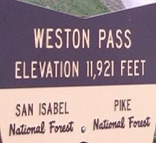
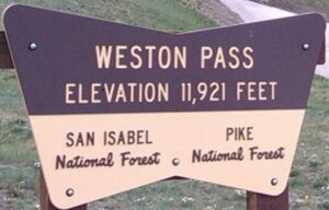
Weston Pass Info & History

The road over Weston Pass, also known as “Road To Riches”, was built in 1860.
- At 11,921 feet, Weston is much lower, and not nearly as steep than the alternate from Denver to Leadville, Mosquito Pass at over 13,000 feet.
Originally Weston served as a wagon road between Fairplay and Leadville and carried mining supplies and travelers over the Weston Peak Pass.
- Today, Weston Pass is a 26.8-mile lightly trafficked, point-to-point trail that goes from near Antero Junction to near Granite.
- Antero Junction is in the South Platte river watershed of Southpark near Trout Creek Pass.
- The small town of Granite, on the Arkansas river, was the Chaffee County Seat back in the day.
- Weston Pass is a fun ride for riders of all levels, and the pass features beautiful wildflowers in the summertime.
- The eastern side is gentler, while the western side is a bit steeper & rougher.

In earlier days, the byway over Weston Pass served as a stagecoach road from Denver to Leadville, two of Colorado’s biggest cities at the time.
- An 1860 gold strike at California Gulch just south of present-day Leadville gave rise to the wagon road over Weston Pass.
- The Pass climbed to the headwaters of the South Fork of the South Platte River, and over the 11,921 foot Weston Pass toward the upper Arkansas River Valley and Leadville.
- Before the Railroads, Weston Pass was the primary route to Leadville for freight and passengers originating in Denver.
- As a result, there was a great deal of stagecoach and freight traffic over the pass.
- When Weston Pass was a toll road around 1878, the Spotswood & McClellan Stage Line had a monopoly on traffic between Fairplay and Leadville.
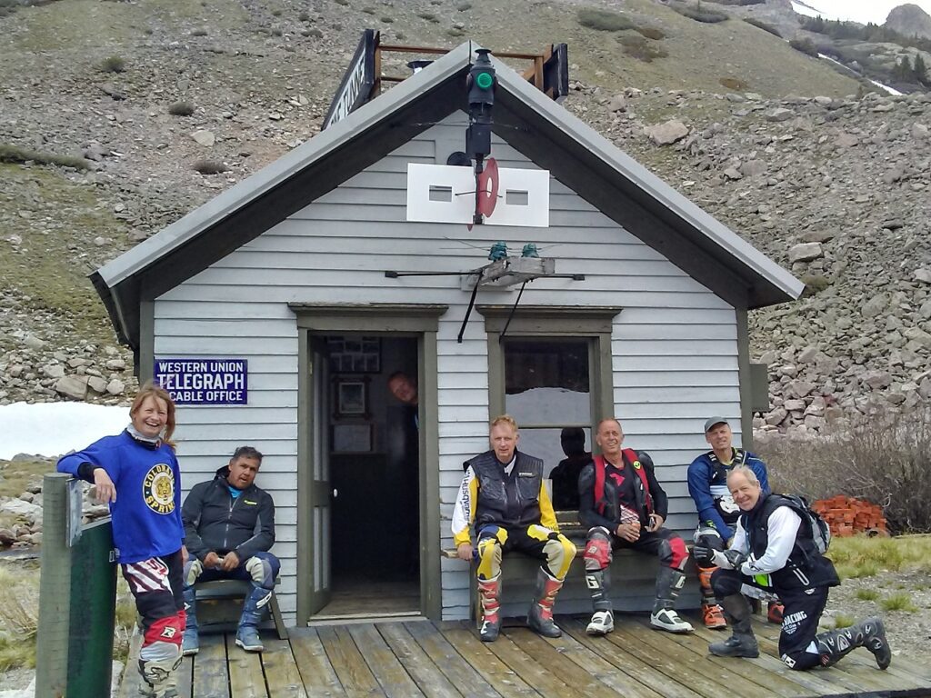
- A telegraph line was also extended over the pass around this time.

In 1880, the Denver & Rio Grande Railroad reached Leadville and traffic over Weston Pass declined dramatically.
- Around that same time, 2 other Railroads, the Denver, South Park and Pacific and the Colorado Midland Railroad also came through Buena Vista via Trout Creek Pass and the Arkansas River, nearly eliminating the need for Weston Pass.
- Many years later, the road was graded suitable for automobile travel, however, during the last decade, the Lake County (West) side has been allowed to deteriorate.

From the Park County side up to Weston Pass, the road is graveled and graded.
- Today, when going from the Arkansas River drainage to South Park, travel over Weston Pass is a nice change from the paved roads.
- Weston Pass is not that steep, and the mountains above the pass tower to over 13,000 feet.

Because Leadville was home to one of the world’s largest mining booms, and because it’s situated among some of the country’s highest mountains, mountain passes are were plentiful to Leadville in every direction.
- The quickest route from one town to the other in the Rocky Mountains is often up and over a mountain.
- Mountain passes—trade routes during the mining era—offer endless opportunities for off-road fun.

More Weston Pass History
The 13,000 foot Buffalo Peaks, formed by volcanic action long after the Mosquito Range uplift, mark the western edge of the 39 Mile Volcano Belt.
- Before there were roads to South Park, early gold rushers using the Santa Fe Trail would head north along Fountain Creek on the Front Range.
- As Pikes Peak came into view, they continued northwest up the creek and over Ute Pass, and then used Buffalo Peaks as a landmark as they entered the South Park valley.
- A crude toll road was built over Weston Pass as early as the summer of 1860.

At least 3 different toll companies operated the road over the next 20 years.
- The early 1860’s saw some busy times for the tollway, but nothing like the hordes that raced for Leadville after the 1877 silver strike.
- For about a two-year period during 1878-79, this road may well have been the busiest in all of Colorado.
As the Denver, South Park and Pacific Railroad built towards the Divide in 1879, the end-of-track was at the wild tent town of Weston, which was established several miles east of Twin Bridges on the South Platte River.
- From there, the Wall & Witter Company alone sent 7 stagecoaches and 11 freight wagons each day to conquer Weston, on their way to Leadville.
- On September 4, 1879, 225 wagon teams were counted as they crossed the summit.
- On the steeper, narrow sections of the road, literal traffic jams were the order of the day; and bloody stage crashes were not uncommon.
- Isham & Co.’s summit house was at the top of Weston Pass, to meet the needs of those who were thirsty and/or in a mood to celebrate achieving the Summit.
You can ride over Weston Pass at 5 rides of the Great Divide Adventure Series.