
Hagerman Pass Info & History and Turquoise lake

Hagerman Pass is a high mountain pass near the Northern end of the Sawatch Range.
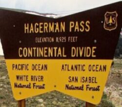
At an elevation of 11,925 feet above the sea level, the Pass is located between the towns of Basalt and Leadville, Colorado.

Hagerman Pass crosses the Continental Divide from the upper Arkansas river valley, to the headwaters of the Roaring Fork river valley in the Rocky Mountains.
- The pass was originally constructed as a railroad line to reach the mines of Aspen in 1885.
- The road is not difficult, but it is one of the highest mountain pass dirt roads in Colorado.
- The pass was named for James J. Hagerman. In the late 19th century, Hagerman was president of the Colorado Midland Railroad, which built the rail line from Leadville to Aspen.
- Hagerman Passwas the first standard gauge railroad built over the Continental Divide in Colorado.
- The Railroad ran from Colorado Springs to Leadville and through the divide at Hagerman Pass to Glenwood Springs and Grand Junction.

Today, Hagerman Pass follows much of his old train line.
- Providing an adventure to get from Aspen and the Roaring Fork River valley near Basalt to the historic silver mining town of Leadville.
- Hagerman and Independence Pass make for an outstanding day long Adventure ride in the Rocky Mountains.
- From Buena Vista and Twin Lakes to Aspen and Leadville.
- The Colorado Backroads Discovery Ride (COBDR) traverses Hagerman Pass from Leadville.

Near the top of Hagerman pass there are great views of the Turquoise Lake area to the east.
- And the Hunter-Fryingpan Wilderness to the southwest.

Originally, the Colorado Midland Railroad traveled thru tunnels through this region to cross the Continental Divide.
- The railroad grade traveled southwest from Leadville along (now under) Turquoise Lake and originally went through Hagerman Tunnel at the Continental Divide.
(All photos are clickable)

In 1885 the Hagerman Tunnel was constructed as part of the Colorado Midland Railroad (1887 to 1922)
- The line connected Leadville with Aspen.
- This first 2,061-foot-long tunnel sits at 11,528 feet altitude just south of Hagerman Pass.

The dark lines in the above photo are some of the 13 snowsheds over the old railroad line.
Hagerman Pass Trestle

As part of the switchbacks to reach the altitude of the Tunnel, the Hagerman Trestle, the most elaborate and spectacular in Colorado, was constructed on the hairpin turn above Busk Creek.
- The Hagerman Trestle was 1,084 feet long, 84 feet high, and included 200 degrees of curvature.


Busk-Ivanhoe Tunnel
In 1891 the Busk–Ivanhoe Tunnel was built as a replacement for the Hagerman Tunnel, at a lower, more direct route.
- The Busk-Ivanhoe Tunnel was a 9,394 feet long railroad tunnel at an elevation of 10,953 feet.
- The Busk-Ivanhoe Tunnel was almost two miles long.
- But it eliminated 13 snowsheds and 12 bridges and trestles that were required to gain the 575 feet of additional altitude to the Hagerman tunnel.
- Starting in 1921, while it was still a railroad tunnel, the tunnel was also used as a water diversion tunnel.
- Moving water from Ivanhoe Lake in the Colorado River Basin to Busk Creek in the Arkansas River Basin.
- Taking water from the Colorado River side of the Divide to the Arkansas River side of the Divide.

Carlton Tunnel
The Line known as Hagerman Pass was scrapped in 1920.
The Busk-Ivanhoe Tunnel was converted to auto traffic in 1922 and re-named as the Carlton Tunnel, a toll tunnel carrying then-State Highway 104.
- In 1917, the line was sold at auction to Albert E. Carlton of Colorado Springs.
- Carlton attempted to revive the railroad’s fortunes, but his stewardship of the railroad coincided with the entry of the United States into the First World War.
- Trans-Colorado traffic that was previously carried by other railroads was directed onto the Midland, which was ill-equipped to deal with the sudden upturn in business.
- The traffic overwhelmed the railroad, and when it became apparent that the Midland was incapable of dealing with the volume of business, the government redirected all traffic elsewhere.
- Much of the line’s grade was incorporated into the modern day U.S. Route 24 in Colorado, in particular the section from Colorado Springs to Buena Vista.
- In 1943 there was a Cave-in on the west end of the Tunnel
- The Colorado Highway Department closed the tunnel and the state discontinued maintenance of the road.
- The tunnel was permanently closed to automobiles in 1943 after that partial collapse.
- The tunnel completely collapsed in 1945.
- Even with the collapse, water is still able to travel through the broken rocks to Busk Creek, which feed into Turquoise Lake.

Water Diversion Tunnel
The city of Aurora owns one half interest of the Busk-Ivanhoe water rights and shares the system with Pueblo Board of Water Works.
- The water rights divert water from Ivanhoe Creek, Lyle Creek, Pan Creek and Hidden Lake Creek.
- All of which are tributaries to the Fryingpan River, for storage in Ivanhoe Reservoir.
- Stored water is transported under the Continental Divide to the Arkansas River Basin through the Busk-Ivanhoe (aka Carlton) Tunnel.
- Flows from the Carlton Tunnel are discharged to Busk Creek, a tributary of the Lake Fork Creek above Turquoise Reservoir.
- Where the water is stored for further conveyance to Aurora, and Pueblo in the Arkansas River.
- This water source provides an annual average of nearly 2,500 acre-feet to the City of Aurora.

Hagerman Pass Road
On the west side of Hagerman Pass, the pass is paved and follows the spectacular Roaring Fork River Canyon to the Reudi Reservoir and to the town of Basalt, Colorado.
- The Colorado 500 stages from near Basalt at the Dallenbach ranch.
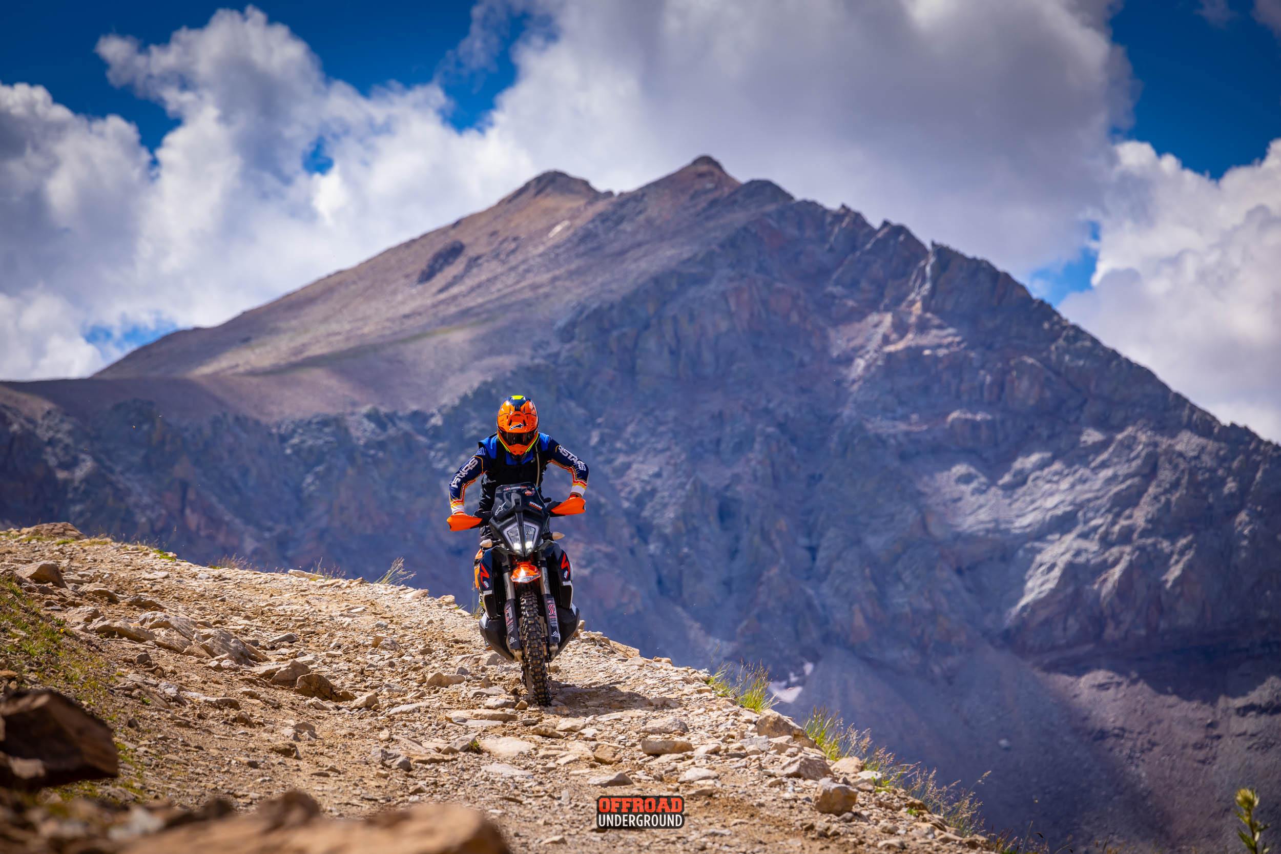
- Hagerman Pass is an epic way to get from Aspen to Leadville.
- It’s an extremely scenic ride, so plan a fair amount of time for the dirt portion, as it’s quite long, and don’t forget your camera.

The ride over Hagerman Pass is definitely worth the effort.
- There are many excellent photo opportunities and fantastic views.
- Towards the top of the pass, the road becomes narrower with some rock ledges.
- Expect a rough road surface; mud and rocks are possible but still easily passable.
- The road has occasionally been blocked by fallen trees.

Turquoise Lake
Five miles west of Leadville and east of Hagerman Pass sits Turquoise Lake, which is a favorite high-altitude recreation destination.
Dammed in the 19th century and named for the rare turquoise deposits found nearby.
- Turquoise Lake offers 1,800 acres or year-round recreation.
- In the summer, Turquoise Lake’s high elevation provides a great respite from the heat.
- With daytime temperatures hovering around 80°, visitors comfortably spend the day.
- The Campgrounds are named for the nearby gold and silver mines and the mineral tycoons who owned them.
- Some campgrounds look out over the water, while others are tucked in forests and meadows.

Boaters can launch from Matchless Boating Site, a boat ramp located on the southeastern shoreline.
Turquoise Reservoir’s 1789 acre impoundment offers good fishing for Brown, Rainbow & Cutthroat trout.
- The reservoir has excellent amenities and is located in one of the most scenic areas in Colorado.
- Turquoise Lake is an ideal fishing destination.

While fishing from a boat in the middle of the lake is ideal, its trout can also be caught from many onshore fishing sites.
Most of the fish caught at Turquoise Lake are under 20 inches.
- But there’s always a good chance of hooking larger, hard to catch species.
- The land surrounding Turquoise Lake is lined with trails and low trafficked, paved roads.
Hagerman Pass is an E-Ticket Adventure Loop

You can tie-in from Independence Pass for an All-day loop from Buena Vista to Aspen and via Hagerman Pass to Leadville.
Ride Hagerman Pass on several rides of the Great Divide Adventure Series

Or Ride Hagerman Pass on a COBDR Adventure

