
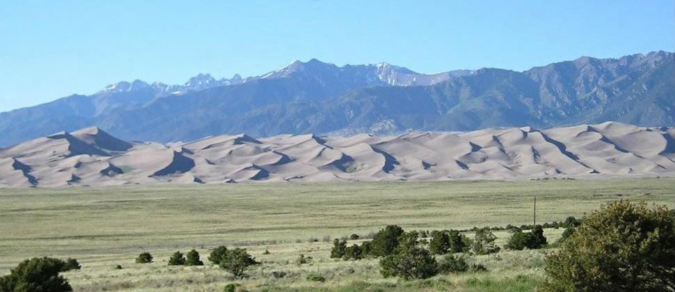
The Great Sand Dunes and Medano Pass.
![]()
The Great Sand Dunes National Park and Preserve and the stunning contrast between the desert-like conditions of the dunes and snow-capped mountains just a few miles away creates one of the world’s most picturesque locales.
- The Great Sand Dunes are North America’s tallest, reaching heights of 750 feet above the valley floor. Another 350 feet of sand lies below the valley floor.
- The highest dune in the park, High Dune, lies at an elevation of 8,691 feet, and is a popular hiking destination.
![]()
GEOLOGY
The Great Sand Dunes’ creation goes back to about 12,000 years ago when the last Ice Age ended.
In the San Juan Mountains, sand that had been ground down by glaciers and trapped in ice during that frigid period was now freed, allowing the prevailing winds from the west and southwest to carry the sand particles across the San Luis Valley.
- The winds have continued to erode the San Juan’s, creating additional fodder for the dunes.
- The Sangre de Cristo’s lie uncharacteristically low between Medano and Mosca Passes, and consequently, the wind funnels through this area of lesser topography and on to the east.
- However, even this lower section of the Sangre de Cristo’s rises over three thousand feet above the valley floor.
- Before the winds can travel up and over the range, they must release their burden of heavy sand, resulting in the accumulation and creation of the Great Sand Dunes in the crook of the Sangre’s between the Mount Herard massif and the Sierra Blanca.

The winds pick up sand from another source outside of the San Juan’s. Following the end of the Ice Age, the San Luis Valley became more arid.
It is now the only true desert in Colorado’s Rockies, with rainfall amounts averaging only 8 inches each year.
- The once lush San Luis Valley dried out even to the point that the northern half of the valley became a closed basin.
- Water draining from the western side of the Sangre’s never reaches the Rio Grande River.
- Instead, the water that doesn’t simply evaporate but delves deep into the sand and gravel floor of the valley, creating aquifers.
- Farmers in the valley, in order to irrigate their lands, have tapped into these deep sources of water by digging numerous artesian wells.

- According to Roadside Geology of Colorado, the sand of the dune fields is composed of “rounded grains of quartz and of volcanic rock,” betraying their origins in the San Juan’s.
- Thus, visitors to the dunes see sand of a darker color than is found in most other dune fields and beaches.
- Interestingly, and perhaps counter intuitively, the Great Sand Dunes’ shape hasn’t changed much over the last hundred years.
- Comparing old photos with new ones reveals that the dunes’ main ridges have moved very little relative to the dune field.
- It is believed this is because the prevailing winds out of the southwest are sometimes balanced by winds that bounce off the Sangre’s and swirl back toward the dunes, as well as by winds that channel over the mountains from the southeast.

HISTORY
Zebulon Pike, for whom Pikes Peak is named, was the first American to document a sighting of the Great Sand Dunes during his exploration in 1807 of the recently acquired Louisiana Purchase.
- More recently in 1932, members of the Monte Vista chapter of the Philanthropic and Educational Organization for Women (PEO) sponsored a bill requesting National Monument status for the Great Sand Dunes.
- The bill passed Congress that same year, and was signed into law by President Herbert Hoover, protecting the 38,000 acres of the main dune field and its immediate surroundings for the first time.

- In 2000, Congressional legislation was passed to upgrade the area to national park status.
- However, the park’s official designation was contingent upon the completion of a complex set of land purchases and transfers.
- Finally, in 2004 the purchase was completed, and the Great Sand Dunes became a National Park.
- As part of this new designation, over 46,000 acres of Forest Service land in the Sangre de Cristo Mountains was transferred into the hands of the National Park Service, becoming the Great Sand Dunes National Preserve.

RECREATION
Beyond exploring the dunes on foot and taking in the incredible and unique scenery, there are a number of other activities that people enjoy when they come to the Great Sand Dunes.
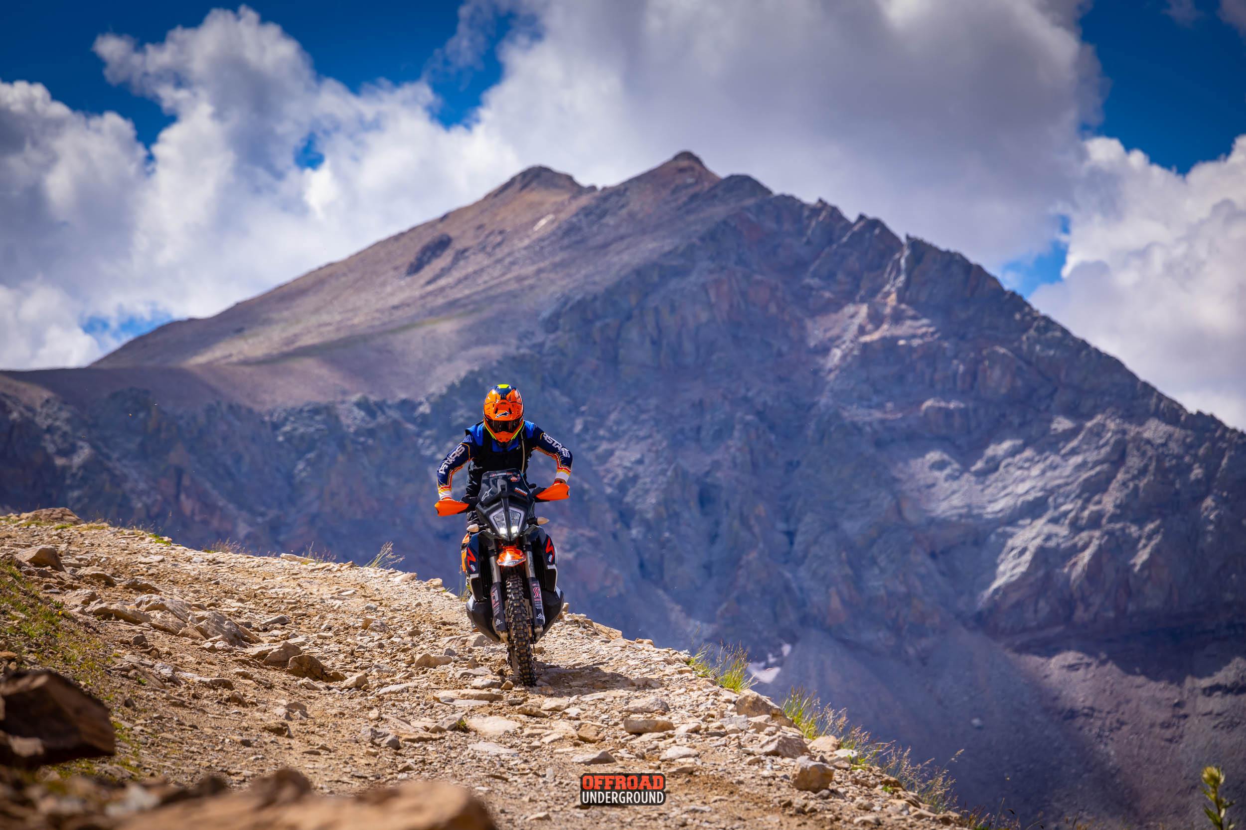
- Some like the challenge of four-wheel-driving or motorcycle riding over Medano Pass Road.
- Medano Pass Road is only open to licensed vehicles.
- Be prepared for this one because more than a few people have gotten stuck on this sandy road.
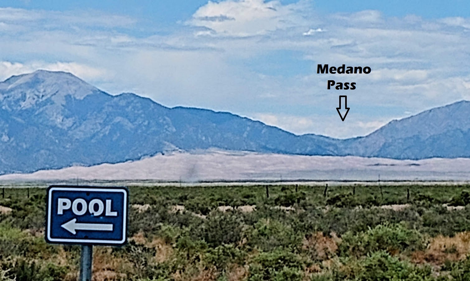
- Other activities include horseback riding and mountain biking, and there are several public hot springs nearby, including the Great Sand Dunes Pool west of the park.
- One of the most unique activities that some people partake in at the dunes is dune-skiing or sandboarding.
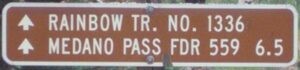
MEDANO PASS ROAD
Medano Pass road is a rough 22 mile road connecting Great Sand Dunes with the Wet Mountain Valley and Colorado State Highway 69.
- Passable only in the warmer months and only with high-clearance 4-wheel drive vehicles or street legal Adventure or Dual Sport Motorcycles
- Medano Pass Road gives access to Medano Pass (elevation 10,040’) and Great Sand Dunes National Preserve.
- This road crosses areas of deep sand, traverses Medano Creek nine times, and passes through excellent habitat for bighorn sheep.
- Snow Runoff makes early summer rather treacherous on the 9 creek creek crossings.

For Exit Tours MC rides we ride from the Wet Mountain Valley headed west over Medano Pass into the GREAT SAND DUNES.
- In late July when the snow run-off has subsided.
- This is the opposite Direction from which most people access the Great Sand Dunes National Park.

If you want to go to the Great Sand Dunes, but do not want to ride the sand of Medano Pass, there is a fun option:
- Pass Creek from just south of Medano Pass Road to La Veta Pass.
- La Veta Pass will take you around Mt. Blanca and you can approach the Dunes from the South instead of the East as on Medano Pass.
INFO ON THE PASS CREEK PASS ALTERNATE
Pass Creek Pass is a hidden gem in western Huerfano County.
- Pass Creek Pass crosses the Sierra Blanca ridge in the south to the Upper Huerfano River Valley in the north.
- Along the way, it passes through a simply beautiful countryside with some very interesting geology.
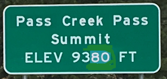
- Pass Creek Pass, elevation 9,380 feet is a mountain pass that is the border between 2 counties in the southern part of Colorado.
- The pass marks the division between the Rio Grande and Arkansas River watersheds.

A drive along Pass Creek Pass is a drive along one of the fault lines that formed the Sangre de Cristo Mountains.
- The road crosses back and forth through upthrust plates of Dakota sandstone and in between vertical granite walls.
- The vertical granite walls testify to the flow of molten magma in the cracks in the ground caused by the action along the fault line roughly 25 million years ago
- The mountains to the west of Pass Creek are old, about 1.7 billion years old, part of the Colorado Orogeny upthrust that put Mt. Blanca, California Peak, the Front Range, and most of the Wet Mountains in place.
- The mountains to the east of Pass Creek are young, about 25 million years old, all part of the igneous intrusions.
PASS CREEK PASS HISTORY
Pass Creek Pass divides the Pass Creek drainage from the Sangre de Christo drainage.
- Originally used by Native Americans, the pass became the route for the Spanish to enter into the San Luis Valley.
- Later, trappers and traders used the pass to sell goods and get supplies from the community around the ealy community of Hardscrabble.
- The early military posts of Fort Garland and Fort Massachusetts relied on the pass as a way to stay connected with communities in the east.
- By the 1850’s the communities around the military outposts were increasing, which required more travel over the pass as a wagon road to bring in supplies.
LA VETA PASS

La Veta Pass bridges the Sangre de Cristo Mountains between the eastern plains and the San Luis Valley at an elevation of 9,413 feet.

Old La Veta Pass was once the main trail route between the San Luis Valley and Walsenburg, first on the narrow-gauge Denver and Rio Grande Railway and later on as a wagon road.
- Old La Veta Pass is now an unpaved and lightly traveled back road.
- La Veta Pass is a Modern Highway connecting Walsenberg and Hwy 25 and Alamosa and Hwy 285.


More Info: https://advtours.com/great-sand-dunes-loop/
PHOTOS: https://photos.app.goo.gl/9GiqskRsPjxGbjCG9